
Geophysical studies over North East region and Deccan Traps (GeoNET)
Chief Coordinator: Anand, S.P. & Members
Subprogram 1 (SP-1): Integrated Geophysical Investigations over Kopili Fault and adjoining regions
Members: Anand S.P., Gautam Gupta, P.B.V. Subba Rao, Amit Kumar, Purushotham Rao.V., B.N. Shinde, Sujit K. Pradhan, M. Laxminarayana, A.K. Prasad, Abilash K.S., E. Karthikeyan, G. Shailaja, K. Tahama
Subprogram 2 (SP-2): North-East Seismicity and Tectonics (NEST)
Members: Shantanu Pandey, Rabin Das, Nongmaithem Menaka Chanu, M. Ponraj, Ganpat Surve, Nava Kumar Hazarika, Abhilash, K. S., Ajish P. Saji, Srinivas Nayak
Subprogram 3 (SP-3): Sub-basalt imaging of the coastal Deccan Volcanic Province and Adjoining Continental shelf using Geo-potential data
Members: Anand.S.P. , B.N. Shinde, M. Lakshminarayana, Awadhesh K. Prasad, Shailja, G.
Subprogram 4 (SP-4): Spatial and temporal Magnetic screening of pollution hotspots in Prayagraj area, Uttar Pradesh
Members: Sujit K. Pradhan, Gautam Gupta, Anup Sinha, Ramesh Nishad, E. Karthikeyan
The North-East region of India (NEI) is geologically unique, defined by its complex geomorphology, tectonics, and seismic activity. Bounded by the Himalayas to the north and the Indo-Burma Ranges (IBR) to the east, NEI experiences significant geological interactions. The Himalayas, stretching about 2,500 km, were formed by the collision of the Indian and Eurasian plates during the Cenozoic era. The IBR marks the eastern boundary, formed by the ongoing subduction of the Indian plate beneath the Burma and Sunda plates. This convergence has created a zone of deformation along the plate boundaries. NEI comprises the Eastern Himalayas, Brahmaputra Valley, Shillong Plateau, and Mikir Hills. The predominantly rigid Precambrian Indian landmass is underthrusting the Eurasian plate at a rate of 4-5 cm/year. It falls under seismic zone V and has experienced two great earthquakes: the 1897 Shillong earthquake (Mw 8.4) and the 1950 Assam earthquake (Mw 8.7), along with over 20 large earthquakes since 1869. The Kopili fault zone, the most active fault in the region, has caused several significant earthquakes, including the April 28, 2021 event (Mw 6.0).
This program aims to develop an advanced lithospheric and geodynamical model using seismological methods like tomography and receiver function analysis. Geodetic observations will help constrain deformation patterns and fault friction states. Utilizing the expanding network of Broadband Seismometer and GNSS stations, the program will enhance the assessment of seismic hazard potential in this tectonically complex region. In addition, integrated geophysical studies including gravity, magnetic, magnetotelluric, VLF-EM, ERT etc., will be undertaken to decipher information of the shallow to deep subsurface across the Kopili Fault Zone (KFZ).
The study, "Spatial and Temporal Magnetic Screening of Pollution Hotspots in Prayagraj Area Uttar Pradesh India," investigates the environmental impact of rapid urbanization and industrialization on magnetic pollutants in Prayagraj. Hosting significant events like Magh Mela and Kumbh Mela exacerbates pollution through heavy traffic and anthropogenic activities. Utilizing road dust, leaf dust, and dusts accumulated on man-made structure, the study assesses urban environmental quality by identifying pollution hotspots. Non-Destructive Testing methods track the origin, concentration, distribution, and movement of magnetic particles. Techniques like Anhysteretic Remanent Magnetization (ARM), magnetic susceptibility studies, and Scanning Electron Microscopy (SEM) with Energy Dispersive X-ray Spectroscopy (EDS) provide insights into fine and coarse-grained minerals, pollutant types, and their sources. By monitoring changes over time, the study underscores the need for continuous pollution tracking and proactive measures to mitigate environmental impacts in urban and suburban areas.
Sub-basalt imaging has always been a challenge to the geo-scientific community. Since the entire Deccan Volcanic Province (including on land and offshore) is blanketed with lava flows, the nature of the underlying pre-volcanic geology and tectonics remains speculative, both in point of view of resources as well as hazards. Hence, it is of paramount importance to probe below the traps using geophysical methods. The acquisition of modern high-resolution airborne magnetic and gravity data in conjunction with advances in the instrumentation and processing methodology has revolutionized the use of potential field methods in oil and gas exploration. Through meticulous processing and interpretation of coarse ground magnetic and gravity data over the DVP, we could map/delineate the structures below the traps in the land area (Figure.2). Under this program we aim to look for sub-basalt structures along the west coast and continental shelf regions using gravity and magnetic data.

Figure 1: Seismicity map (1762 – 2022) of North East India indicating major tectonic structures and convergence zones. The two great earthquakes in the region are represented as red stars. Two profiles A – A’ and B – B’ shows the seismicity as depth sections. The deeper earthquakes in the profile section represents the subducting Indian slab.
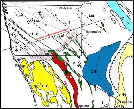
Figure 2: Interpreted map of the Deccan Volcanic Province (Rajaram et al, 2017) from the integrated analysis of gravity and magnetic data superimposed on the regional scale geologic and tectonic map (redrawn from GSI 1993, 2001, 2010) of Peninsular India, showing the sub-Deccan Trap continuation of the Dharwar Craton and the associated schist belts. Hatched areas represent the interpreted NW extension of the schist belts (the width is arbitrary). KLZ, Kurdwadi Lineament Zone (from Peshwa & Kale 1997). Schist belts are in green. WDC, Western Dharwar Craton (yellow); EDC,Eastern Dharwar Craton; CG, Closepet Granite (red); CB, Proterozoic Cuddapah Basin (blue); KB, Proterozoic Kaladgi Basin; BB, Proterozoic Bhima Basin; ChB, Chikotra Basin; DT, Deccan Traps; GG, Gondwana Godavari Graben (cyan), Alluvium (pale yellow).
Chief Coordinator: Anand.S.P
Coordinator : Shantanu Pandey
Members : Gautam Gupta, P.B.V. Subba Rao, Anup Sinha, Ramesh Nishad, Amit Kumar, Purushotham Rao, Rabin Das, Nongmaithem Menaka Chanu, B.N. Shinde, Ganpat Surve, M. Ponraj , Nava Kumar Hazarika, Sujit K. Pradhan, M. Laxminarayana, Awadhesh K. Prasad, Abilash K.S., E. Karthikeyan, Ajish P. Saji, Srinivas Nayak, G. Shailaja, K. Tahama, Research Scholars & Project Associates


